Although the English conquered New France after the Battle on the Plains of Abraham at Quebec City in 1759, settlement did not begin in the Toronto area until 1793. The lands surrounding Toronto (including all of Etobicoke) were acquired from the resident Ojibwa Mississauga aboriginal nation as part of the Toronto purchase in 1787. Later confirmed in 1805, the treaty established the rights of the Mississauga aboriginal nation to continue cultivating the lands at the mouth of Etobicoke Creek.
It was the Mississauga nation which would give the place names to many South Etobicoke locations. Mimico got its name from the fact that the mixed hardwood and evergreen forest at the mouth of Mimico Creek was one of two favourite nesting places of the Passenger Pigeon in the region, and hence "the home of the wild pigeon". Etobicoke is also an aboriginal name which means "where the Alders grow".
In 1791 Colonel John Simcoe was appointed by the British Government as the Lieutenant Governor of Upper Canada. He left England and arrived to take over his new responsibilities in the fall of 1792 at the provincial capital of Newark (present day Niagara-on-the-Lake). Fearing that the settlement was vulnerable to attack by the Americans just across the Niagara River, Simcoe relocated the provincial capital to Toronto in 1793. The only European inhabitants near the future capital were Jean-Baptiste Rousseaux and his family, who lived in a house on the east bank of the Humber River, a short distance from its mouth. The family had established themselves there as early as 1770 when Rousseaux's father was granted a license to trade in the area . It was Rousseaux who acted as the pilot for Simcoe's ship the Mississauga and guided it safely into Toronto Bay.
Shortly after Simcoe's visit, Joseph Bouchette was sent to survey the new harbour. Bouchette remarked on "the untamed aspect which the country exhibited when first I entered the beautiful basin....Dense and trackless forests lined the margin of the lake, and reflected their inverted images in its glassy surface...the bay and neighbouring marsh were the hitherto uninvaded haunts of immense coveys of wild fowl". Bouchette found little occupation of the area by any aboriginal group. The aboriginal villages on the Humber River and elsewhere had been abandoned, and only two Mississauga families were found living near the shore of Toronto Bay.
Into this unspoiled wilderness, settlers came. A 10 block military grid adjacent to the mouth of the Don River was surveyed for the new town and construction soon began. The majority of the wood for the construction of the early buildings of York came from the saw mill established in 1793 on the west side of the Humber River in the new Township of Etobicoke. The mill site, which also included Toronto's first shipyard, was built to take advantage of the superior wood found in this location.
In 1795, Simcoe reserved 4,150 acres of nearby land for members of the Queen's Rangers. This strategy would have ensured that there would always be an army of men on hand in case of an American invasion. But most soldiers never saw their land and quickly sold it off to speculators. These lands included South Etobicoke, of which the largest amount of 1,530 acres was granted to Colonel Samuel Smith. In 1799, Smith built a home near the mouth of Etobicoke Creek. These large military land grants, now largely owned by speculators, would slow the development of the south Etobicoke area, and hence the environmental destruction that went along with it.
In 1799 Sir David Smyth published his book A Short Topographical Description of His Majesty's Province of Upper Canada in North America and described the area as follows:
...a little to the westward of the garrison are the remains of the old French fort Toronto; adjoining to which is a deep bay, that receives the river Humber, on which are saw mills belonging to government: a little way up the river the government yacht is building. Further to the westward (that is, between the Humber and the head of Lake Ontario) the Tobycocke [Etobicoke], the Credit, and two other rivers, with a great many smaller streams, join the main waters of the lake; they all abound in fish, particularly in salmon;... The tract between the Tobycocke [Etobicoke] and the head of the lake, is frequented only by wandering tribes of Missassagues.
During the pioneer stage of development, the main activities of the settlers was to open up the area, clear their land, erect a log cabin and put in their first crop of potatoes, corn and squash. The Lake Shore Road was the main route through south Etobicoke. By 1798, this route (which had originally been an aboriginal path) was widened and opened as a road. A ferry service was available at the mouth of the Humber River. It was replaced by a bridge in 1809. The Lake Shore Road was the principle road connection between York and Niagara, and by 1826 stagecoaches began to make regular trips between the two points.
During this early period of growth, the Humber River valley, and the lands to the west were utilized by the inhabitants of York for recreational purposes. Lady Simcoe recorded such an excursion that occurred on September 4, 1793, and remarked on the "great deal of Hemlock Spruce on this river", and the "beautiful species of Polygala" flowers that bloomed along its banks. And on September 19, 1800 Joseph Willcocks recorded in his diary:
I went to the Humber on a pleasure party with Mr. & Miss Russell, Mr. and the Miss Willcock's, Mr. Weeks and Doctor Baldwin. We left York at 10 oClock and reach'd the Humber in Mr. Jarvis's Boat at half past 12. Walked about for an hour & dined at half past 1. We had for Dinner a piece of Cold Roast Beef, Cold ham, cold chickens & hot Stewed Wild Ducks. We all arrived safe at home at 5 oClock in the Evening.
Many of the military grants in south Etobicoke were held by speculators who made no improvements whatsoever. In 1818 while on his way to visit Colonel Smith, then Chief Administrator of the province, Robert Gourlay commented that:
For many miles not a house had appeared when I came to that of Colonel Smith, lonely and desolate. It had once been genteel and comfortable but now was going to decay. A vista had been opened through the woods towards Lake Ontario; but the riotous and dangling undergrowth seemed threatening to retake possession from the Colonel of all that had once been cleared, which was of narrow compass...Not a living thing was to be seen around. How different it might be, thought I, were a hundred industrious families compactly settled here out of the redundant population of England.
In 1805, the population of the township amounted to 84 inhabitants. This increased to 137 by the time the second census was taken in 1809. However, by 1830 the population had increased to 1,016, indicating the popularity that the area held with new settlers.
At first, the impact on the environment was negligible. In fact, the creation of cleared areas increased productive wildlife habitat along the forest edges. The quail was an example of a species that benefited from the clearing of the forests, as they "... were unknown in the dense forests of Upper Canada before they were cleared."
However, as the destruction of the forests increased, so did the loss of animal species. As the destruction continued even Mimico's namesake, the Passenger Pigeon began to be threatened. Once counted in the billions, the Passenger Pigeon began to decline as its breeding habitat was destroyed, and millions of birds were killed by farmers, who salted them for sale in local markets. The number of birds was such a surprising sight that even Lady Simcoe was moved to record her reaction in her diary. On November 1, 1793 she wrote:
The flights of wild Pidgeons in the Spring and Autumn is a surprizing sight. They fly against the wind so low that at Niagara the Men threw sticks at them from the Fort and killed numbers, the air is sometimes darkened by them. I think those we have met with have been particularly good....Coll. Butler was observing that they build where there are plenty of Acorns but do no feed within 20 miles of the place, reserving that stock of Provisions till the young ones can leave their Nests and then scratch the Acorns up for them.
One of their favourite places to nest in the Toronto area was the "mixed hardwood and evergreen forest" along the banks of the mouth of Mimico Creek. However, by about 1900 this bird, which use to blacken the skies for hours during migration season, was effectively extinct. The last bird in Ontario was shot at Penetanguishene in 1902, and the sole survivor of the species died in the Cincinnati Zoological Gardens in September 1914.
Added to the destruction resulting from the clearing of land by settlers was the destruction created by the cutting of timber for building material and shipbuilding. Timber along the banks of the Humber River in the King's Mill Reserve was especially sought after. The Kings Mill burned to the ground in 1803, but it was later rebuilt and the destruction continued. In order to ensure that supplies of timber remained constant, the government continued to enlarge the Reserve. Beginning as 726 acres in 1793, it was enlarged to 850 acres in 1799, and then to 1,181 acres in 1803, at which stage it included all the land east of present day Royal York Road to the Humber River, and from The Queensway in the south to Government Road in the north. In some years 500,000 feet of lumber "was loaded at the mouth of the river, bound chiefly for Britain and the United States". By 1822 "most of the timber on the mill reserve have been cut off".
Forests hold rainwater and then slowly release it over time. Therefore, as the total area of tree coverage decreased so did the water table. Initially the changes were subtle, but as more trees were cut the decreasing water table became a problem for the many watercourses which flowed through the Township of Etobicoke toward the lake. Many of the smaller creeks dried up completely, and the larger ones began to experience fluctuations in flow.
These fluctuations began to have a severe economic impact on the many mills located on these watercourses. In South Etobicoke, William Gamble built a saw mill at the mouth of Mimico Creek in 1823, and sometime later two other saw mills were constructed on the lower Etobicoke Creek. As the increase in deforestation continued, the water table decreased, resulting in lower levels of water in the adjacent rivers and streams. This, combined with the increase in water level fluctuations due to runoff from the land caused many problems for the mills. Many lacked adequate quantities of water to drive the mill stones, or received so much water at one time that the dams were overwhelmed and destroyed.
Moreover, decreased water levels had an impact on the fish. In the early years of settlement, many settlers remarked on the abundance of fish, especially the highly sought after salmon, available in the Humber River and other streams flowing into Lake Ontario. "One settler wrote, 'It looked as if I could walk across the river on their backs'. Another recorded, 'I was impeded in paddling my canoe across the stream by the multitude of salmon. For the first meal in our wilderness home we enjoyed a large specimen of this prince of fish cast out by hand from a creek flowing beside our log cabin'". However, the mill dams began to prevent many of the fish from reaching their spawning grounds further up stream, and those that did found many of them suffocated by saw dust from the many saw mills.
By about 1840 the Township of Etobicoke had generally completed the pioneer stage of its development and had emerged into an era of settled agriculture. By 1842 forest depletion in Etobicoke Township had reached 50% and the population of the area reached 2,467. As deforestation continued, further disrupting the flow of ground water, the rivers and streams in the area flooded causing extreme damage to mills and other properties. The first severe floods occurred in 1850. The village of Weston, originally built on the west side of the Humber River was destroyed by floods and many of the mills were either damaged or had their dams washed away. This was followed by other floods in 1851, 1859, 1878 and 1880, each more severe than the last. The flood of 1878 destroyed all the mills on the Humber River along with a number of houses resulting in loss of life. The unreliable water fluctuations in the rivers made mill activities difficult and many of them closed or were converted to more reliable steam power. By 1870, there was not enough water in the Etobicoke Creek to turn the great wheel at the Dundas Road mill built by the Silverthorne family. Water fluctuations in the rivers also destroyed fish habitat and devastated cold water species, including the salmon.
By 1850 the Lake Shore Road had been sold to a private company and planked. A little later wharves were built at the mouth of Mimico Creek and the Humber River to export agricultural products by ship and receive imported finished goods. In 1855 the Great Western Railway was built through the area on its way to Hamilton. This lead to a plan for a new workers community centered around Christ Church in Mimico, but the idea never got off the ground and only a few homes were built. However, despite these changes growth was slower than the rest of Etobicoke, and the environment was given a respite from further damage. A large amount of forest cover, including the 500 acres of pine and oak owned by the Smith family, remained. The large productive wetlands at the mouth of the Etobicoke and Mimico Creeks and Humber River also remained and provided important habitat for fish and other wildlife.
However, over the years these remaining woodlots steadily decreased. In 1871, Samuel Smith Jr. sold his 500 acres of land to James Eastwood, who found ready buyers for the vast forest of trees on the property. All were cut within a few years. By the mid 1880s the forests that lay in the Etobicoke and Mimico Creeks, and the Humber River valleys were all that remained of the original forest cover.
Between 1881 and 1891, the City of Toronto experienced a tremendous increase in population. This increase in population spilled into the surrounding lands, and as a result south Etobicoke began its transformation from an agricultural community to an urban/industrial suburb.
Some suburban development began in Mimico as early as 1870, but it was small and limited to a few lots along the lake. However, the first organized and planned step in the transformation began in 1883 when James Eastwood sold 75 acres of the old Smith Estate to a syndicate of entrepreneurs who intended to develop a new resort community. In 1884, Thomas J. Wilkie registered the plan for a new development consisting of 219 cottage lots. Eventually named Long Branch Park, this resort community was served by a number of ferries which plied the waters along the north shore of Lake Ontario from Toronto. The resort was an immediate success and by 1888 the steamships carried more than 50,000 "pleasure seekers" to Long Branch.
The second step in the transformation was the construction of the Victoria Industrial School in 1887. This provincial facility, to rehabilitate male juvenile offenders, was situated on a large acreage of land north of the railway tracks near present day Islington Avenue and Judson Street. It operated until 1935.
Another significant development was the construction of the Mimico Asylum. This new hospital facility, developed as a branch hospital of the Toronto Asylum on Queen Street, was established on 55 acres of the former Goldthorpe farm, east of Kipling Avenue. In 1903, the McNeil farm on the west side of Kipling Avenue was added and the lands were utilized for agricultural purposes. The hospital operated on the site for another 76 years.
In 1890 the Mimico Real Estate & Security Company began construction of a new industrial suburb on 550 acres of land further east on the Lake Shore Road. Calling the embryo town "New Toronto", and stating that the new community "promises in time to equal, if not surpass Old Toronto as a commercial centre". The consortium of manufacturers constructed new industrial enterprises in the area and subdivided the land for residential development.
In order to facilitate the growth of their newly acquired lands, the main investors also became involved in the construction of a radial streetcar line to serve the area. The Toronto and Mimico Electric Railway began construction of the new radial line along the Lake Shore Road in 1892, reached the mouth of Mimico Creek in July 1893, Kipling Avenue by September 1893, and eventually reached Etobicoke Creek by 1895. A number of factories were built within a few years. However, the severe economic depression of the mid 1890s bankrupted the Mimico Real Estate Security Company and most of the new factories closed.
Suburbanization of south Etobicoke also began to change the lakefront east and west of Mimico Creek. East of Mimico Creek, the thin strip of land between the Lake Shore Road and Lake Ontario continued to remain a popular place for pleasure day trips from the City of Toronto. In fact, the collection of hotels around the mouth of the Humber River made it a "noted centre for taverns and sporting and social life." Establishments such as these began in the 1850s, and over the years more were built by the likes of Octavius Hicks, Charles Nurse and John Duck who "spared no expense in beautifying the extensive pleasure-grounds" of Wimbleton House.
West of Mimico Creek along the Lake Ontario waterfront a number of large estates were built. With "its clear waters, long unobstructed beach and stately shade trees" the area began to look attractive to Torontonians as early as the 1870s. However, the construction of the radial line in the 1890s made the area accessible to the City of Toronto, and wealthy families began to move into the area. Despite the depression in the 1890s, Mimico also attracted a few industrial enterprises including the Ontario Sewer Pipe Company, and a number of small brick making factories.
By the turn of the 20th century, most of south Etobicoke was subdivided into lots by development companies as a series of new communities. Promoted by infrastructure improvements such as the paving of the Lake Shore Road in 1917, and its widening and the double tracking of the streetcar lines in 1928, suburban development flourished until most of the area south of the CNR tracks and a portion of southern Alderwood was fully urbanized prior to WW II. This new pattern of growth accelerated the deterioration of the local environment.
Mimico was a desirable community for those wishing to flee the dirt and grime of the nearby city. In 1905, the community of over 300 demanded political independence and the York County Council created Mimico as a Police Village. The following year the Grand Trunk Railway decided to establish its main marshalling yards in the area, and the resulting influx of new jobs created a demand for more housing. Within a few years the population grew to 800. The influx of new residents enabled the community to become an independent Village in 1911, and as a result, new subdivisions were put on the market to satisfy the need for housing. The 35 acre Crescent Point was launched in 1910, with an emphasis on the beautiful lake setting among the estates of the "best class of people". This and other developments promoted strong growth, and Mimico developed primarily as a residential community, and was known as one of the prettiest Toronto suburbs. The community remained relatively stable until the end of WW II, at which time the descendants of many of the large lakefront estates, unable to afford the maintenance and taxes, began to sell them to developers and speculators. Some were operated as restaurants or nursing homes for a period of time, but then began to be converted for low rise apartment development. The first property to be built on was the former Franceschini Estate in 1950. This inevitably lead to more construction as developers attempted to meet the post war housing shortage, and this resulted in unique destruction to the environment.
In New Toronto, development continued with new businesses occupying many of the vacant industrial buildings and even constructing new factories. Reg. N. Boxer, producers of paper products opened for business in 1903 and Brown's Copper and Brass Rolling Mills opened next door in 1910. With the increase in population attracted by these new industries the area was able to have itself declared a Village in 1913. During WW I a number of new industrial enterprises moved to the area. These included, the Fabrikoid Division of Canadian Industries Limited which began construction on their new plant in 1915, the Goodyear Tire Company in 1917, and the Donnell and Mudge tannery in 1918.
After the war, industrial development continued. Anaconda American Brass Limited came to the area and rented the existing Brown's Copper and Brass plant in 1922. In 1928 Anaconda purchased the property and reconstructed the plant. By 1923, the population increased to 5,000 and New Toronto became a Town.
The communities industrial success continued during the Great Depression of the 1930s. During those trying times, three other major industries were attracted to the area including Campbell Soup in 1931, Gilby's Distillery in 1933 and Continental Can in 1935.
At the turn of the century, the Long Branch community remained a popular destination. In 1910, the agricultural lands on either sides of the Lake Shore Road were subdivided. The new subdivisions were referred to as The Pines, Pine Beach, The Lake Shore Gardens, and The Lake Shore Gardens Annex. The lands north of the Lake Shore road and west of the Long Branch resort community however were held by the Jockey Club for the location of a future racetrack, and by Ontario Hydro for the construction of a future radial terminal (as part of Sir Adam Beck's plan). South of the Lake Shore Road the lands held by the Eastwood family were subdivided in 1920. The 406 lot plan covered the entire property including the river valley, the island at the mouth of Etobicoke Creek, and the thin spit of sand which projected into Lake Ontario.
Long Branch developed slowly, and became a Village in 1931. The blocks of land west of 32nd Street north of the Lake Shore Road were not released for development until after WW II. These lands would provide the community with some industrial development, in addition to the small industrial areas along the south side of the CNR rail line.
The lands south of Horner and west of Browns Line were developed as the Alderwood community after WW I. However, Alderwood wouldn't see the bulk of its growth until the end of WW II. Development here would be the typical 1950s suburban housing which occurred in most areas of the city. In addition, a large section of land was reserved for industrial purposes. With quick and convenient access to downtown Toronto via the Queen Elizabeth Way, especially after the Gardiner Expressway was built in 1953, these industrial areas soon filled up.
Prior to the end of WW II residential and industrial development in the area essentially worked within the existing landscape and few wide scale changes were made to the basic topography. Land unsuitable for development was usually set aside as parkland. For example, when Robins Real Estate Limited began development of their West Point project in New Toronto in 1913 they reserved the land in and around the (Jackson) creek that emptied into Lake Ontario for parkland. However, the construction boom that followed WW II required more lands for development. As a result, lands originally seen as unsuitable for development were now filled in and either built upon or used for other purposes.
In addition to the disruption of the landmass itself, there were also impacts on the soil and groundwater as local industry and the railways, whether through carelessness or lack of foresight, began to contaminate the areas close to their facilities. With a history of industry going back to the beginning of the 1890s New Toronto was especially hard hit, but other areas suffered as well.
Waste management became an issue as the population increased. In response, the Towns of Mimico and New Toronto set up the Union Sewerage Commission in 1915. A garbage incinerator and a sewage plant, were soon constructed on separate sites in Mimico to deal with the problem. In 1947, the incinerator was rebuilt in a new location adjacent to the sewage plant. These new facilities added to the existing problem of soil and groundwater contamination in the area.
As the area urbanized, paved surfaces such as roads and driveways, affected the water levels in the remaining watercourses. Under such circumstances the flow of water was greater during wet events, and minimal in between, playing havoc with fish and wildlife which require constant even flows of water. However, the greatest impact was from the direct alteration of the landscape which resulted in the elimination and the destruction of habitat as creeks and riverbeds were filled in. At the beginning of the 20th century, only three major and five minor watercourses remained of the numerous creeks and streams which once flowed through South Etobicoke.
Wednesday, October 14, 2009
Bonar Creek
Bonar Creek, which is a tributary of Mimico Creek, had its headwaters just north of Superior Creek and flowed in a southeasterly direction until it joined up with the main watercourse at its vast wetland at Lake Ontario.
It continued to flow until about 1950, when most of it was placed in a sewer and parts of its former watercourse was filled in and topped with warehouses and a sewage treatment plant. In 1957, the operators of the McGuiness Distillery, which was located east of Grand Avenue – now the Mystic Pointe development - began to fill in the remainder of the creek’s ravine in order to construct a number of warehouses north of Manitoba Street.
Today only the lower portion of the creek below the CNR rail line flows above ground though it has been channelized.
However, restoration of the creek is in process. The Bonar Creek Bonar Stormwater Management Facility and Legion Road Extension Municipal Class Environmental Assessment will result in the restoration of the wetland that historically existed in this location.
Confluence of Bonar and Mimico Creeks 1889 - Archives of Ontario
Superior Creek
The headwaters of Superior Creek originated near present day Kipling Avenue, just north of the Gardiner Expressway, and flowed in a southeasterly direction to Lake Ontario.
 Superior Creek 1856 - a deeply incised valley running in an easterly direction from Royal York Road just south of the Great Western Rail line built in 1855. Christ Church is in the top left hand corner - J.O. Browne's Plan of the Town of Mimico 1856.

The 1912 map shows exactly where the creek once flowed through this part of Mimico. Complaints regarding pollution in the creek from local industry and the nearby railway were being made by the local populace. As a result, the lower portion of the creek was modified and piped in 1915 by the Town of Mimico as an infrastructure project to alleviate local unemployment.

The upper portion of the creek continued to flow freely across north Mimico until construction of new homes after the Second World War led to citizen complaints over pollution and safety.
 Superior Creek flowing across Etobicoke township just north west of Mimico - 1952.
Articles first began to appear in the Advertiser in the early 1950s when the residents of north Mimico began to complain loudly to Mimico Council of perennial flooding. One resident even went so far as to threaten a tax boycott until the creek was gone. In December 1954, the Etobicoke-Mimico Conservation Authority commissioned a report on the feasibility of placing the creek in a sewer through Mimico. However it does not appear that the work was completed until sometime after 1965. Today, nothing remains of the creek, and a river of black asphalt covers the lower portion of the creek where it once flowed in a wide and steep ravine down Stanley Avenue south of Station Road.
 Superior Creek Lane - commemorating Superior Creek where it once flowed through a townhouse development north of Evans Avenue © Michael Harrison 2009
 Superior Creek 1856 - a deeply incised valley running in an easterly direction from Royal York Road just south of the Great Western Rail line built in 1855. Christ Church is in the top left hand corner - J.O. Browne's Plan of the Town of Mimico 1856.
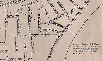
Superior Creek 1912

The 1912 map shows exactly where the creek once flowed through this part of Mimico. Complaints regarding pollution in the creek from local industry and the nearby railway were being made by the local populace. As a result, the lower portion of the creek was modified and piped in 1915 by the Town of Mimico as an infrastructure project to alleviate local unemployment.

Complaint made in 1914 about the sanitary condition of Superior Creek.
The upper portion of the creek continued to flow freely across north Mimico until construction of new homes after the Second World War led to citizen complaints over pollution and safety.
 Superior Creek flowing across Etobicoke township just north west of Mimico - 1952.
Articles first began to appear in the Advertiser in the early 1950s when the residents of north Mimico began to complain loudly to Mimico Council of perennial flooding. One resident even went so far as to threaten a tax boycott until the creek was gone. In December 1954, the Etobicoke-Mimico Conservation Authority commissioned a report on the feasibility of placing the creek in a sewer through Mimico. However it does not appear that the work was completed until sometime after 1965. Today, nothing remains of the creek, and a river of black asphalt covers the lower portion of the creek where it once flowed in a wide and steep ravine down Stanley Avenue south of Station Road.
 Superior Creek Lane - commemorating Superior Creek where it once flowed through a townhouse development north of Evans Avenue © Michael Harrison 2009
Tuesday, October 13, 2009
Jackson Creek
Jackson Creek once drained a large area of south Etobicoke, originating just north of Bloor Street West near Highway 427 and flowing in a southeasterly direction to Lake Ontario. Miraculously it still flows through most of its upper reaches north of the Gardiner Expressway, surrounded by the industrial and commercial enterprises that moved in after the Second World War. Had this area been developed as a residential community, the creek would most likely have been buried. Instead, it was shunted off to the sides of large industrial and commercial properties, and though it has been channelized, it is now largely vegetated by trees and other riparian vegetation like bullrushes.
The headwaters currently lie just north-west of the Russell Food Equipment building on Coronet Road. The creek flows along the west side of the rail spur that continues north to the main rail line. The creek once flowed further to the north but the culvert that once contained it is now dry, the food distribution warehouse on the other side of the tracks long ago cut off its source. The creek flows south into a culvert, under North Queen Street, around the former Sam's Club site and then flows freely across the Canadian Linen property, under The Queensway, and south between two car dealerships until it enters a culvert and flows under the Gardiner Expressway.
 Jackson Creek flowing across the Canadian Linen site west of Atomic Road and north of The Queensway - looking north, 2008 © Michael Harrison 2009
Further south, in the residential community of Alderwood, its course meanders through Douglas Park south of Evans Avenue, and along the western boundary of the now closed Alderwood Collegiate on Valermo Drive. These two portions of the watercourse are totally devoid of any riparian vegetation, and are essentially grassed ditches with intermittent flow.
 Jackson Creek looking south in Douglas Park, south of Evans Avenue west of Islington Avenue 2008 © Michael Harrison 2009
 Jackson Creek looking north along west side of former Alderwood Collegiate Property, Valermo Drive 2008 © Michael Harrison 2009
South of here it originally flowed in a south easterly direction through what became a residential community, south of Horner Avenue, under the railway tracks across Town's Road and into New Toronto. The large culvert just south of Town's Road near the end of the street is still there. This would have carried it under the railway track. If you stand there you can hear flowing water. Is this Jackson Creek imprisoned underground?
In New Toronto it originally flowed above ground but was piped at some time. I do not know when. According to the 1811 Patent Map it flowed down to present day Kipling Avenue and Lake Shore Blvd West. This low point continues to exhibit flooding during summer storm events. This is the water following its natural drainage pattern established hundreds of years ago. South of Lake Shore Blvd West it enters the Hospital Grounds.
 Map of North and Jackson Creeks flowing across the Hospital Grounds 1936 - Jackson Creek cut across the north east corner of the site.
On the Hospital Grounds its former valley can still be seen. Today it is called the "swale". Underneath Jackson Creek flows through a storm sewer along its former course.
The Swale on the Hospital Grounds - looking south- the former - now modified valley of Jackson Creek 2008 © Michael Harrison 2009
 Bridge over Jackson Creek on the Hospital Grounds circa 1910
East of the Hospital Grounds it cut through the Jackson Farm property. Jackson Creek ended its journey at Lake Ontario just east of here.

When the property containing the mouth of the creek was developed in 1917 by Robins Real Estate as their West Point development they left it alone.
 Mouth of Jackson Creek - West Point Development - Robins Real Estate 1917
The headwaters currently lie just north-west of the Russell Food Equipment building on Coronet Road. The creek flows along the west side of the rail spur that continues north to the main rail line. The creek once flowed further to the north but the culvert that once contained it is now dry, the food distribution warehouse on the other side of the tracks long ago cut off its source. The creek flows south into a culvert, under North Queen Street, around the former Sam's Club site and then flows freely across the Canadian Linen property, under The Queensway, and south between two car dealerships until it enters a culvert and flows under the Gardiner Expressway.
 Jackson Creek flowing across the Canadian Linen site west of Atomic Road and north of The Queensway - looking north, 2008 © Michael Harrison 2009
Further south, in the residential community of Alderwood, its course meanders through Douglas Park south of Evans Avenue, and along the western boundary of the now closed Alderwood Collegiate on Valermo Drive. These two portions of the watercourse are totally devoid of any riparian vegetation, and are essentially grassed ditches with intermittent flow.
 Jackson Creek looking south in Douglas Park, south of Evans Avenue west of Islington Avenue 2008 © Michael Harrison 2009
 Jackson Creek looking north along west side of former Alderwood Collegiate Property, Valermo Drive 2008 © Michael Harrison 2009
South of here it originally flowed in a south easterly direction through what became a residential community, south of Horner Avenue, under the railway tracks across Town's Road and into New Toronto. The large culvert just south of Town's Road near the end of the street is still there. This would have carried it under the railway track. If you stand there you can hear flowing water. Is this Jackson Creek imprisoned underground?
In New Toronto it originally flowed above ground but was piped at some time. I do not know when. According to the 1811 Patent Map it flowed down to present day Kipling Avenue and Lake Shore Blvd West. This low point continues to exhibit flooding during summer storm events. This is the water following its natural drainage pattern established hundreds of years ago. South of Lake Shore Blvd West it enters the Hospital Grounds.
Map of North and Jackson Creeks flowing across the Hospital Grounds 1936 - Jackson Creek cut across the north east corner of the site.
On the Hospital Grounds its former valley can still be seen. Today it is called the "swale". Underneath Jackson Creek flows through a storm sewer along its former course.

The Swale on the Hospital Grounds - looking south- the former - now modified valley of Jackson Creek 2008 © Michael Harrison 2009
When the entrance to the Hospital was developed in the late 19th century an ornate stone bridge was built across it. The balastrade has been removed but the historic bridge remains buried under fill waiting to be resurrected.
 Bridge over Jackson Creek on the Hospital Grounds circa 1910
East of the Hospital Grounds it cut through the Jackson Farm property. Jackson Creek ended its journey at Lake Ontario just east of here.

Photo of the mouth of Jackson Creek, circa 1900
When the property containing the mouth of the creek was developed in 1917 by Robins Real Estate as their West Point development they left it alone.
 Mouth of Jackson Creek - West Point Development - Robins Real Estate 1917
The mouth of Jackson Creek remained relatively undisturbed until 1947, when it was redirected into a sewer and flowed directly into Lake Ontario at the foot of Eleventh Street. Its former mouth remained part of Rotary Park until 1958, when its rocky beach was deemed unsafe by New Toronto Council and was covered with fill as part of a $90,000 park improvement plan.
North Creek
North Creek, originally drained a large area of south Etobicoke, flowing in a southeasterly direction to Lake Ontario from its headwaters near the interchange of present day Gardiner Expressway and Highway 427.
 North Creek flowing through north Long Branch 1952 - Toronto Reference Library
Most of the creek was placed in a sewer sometime after 1958, following four years of complaints, as chronicled in the Advertiser, by residents that industry was dumping waste in the creek. At a Long Branch Council meeting in 1954, Councillor Maurice Breen openly admitted that this was a problem, but explained that the local sewage plant was already overloaded, and that the city ‘cannot allow the industries to send their huge quantities of water through the plant so at present they have no alternative but to deposit some liquid waste in the creek.’ After repeated calls for action from local council, the Etobicoke-Mimico Conservation Authority commissioned a report to place the creek in a sewer through Long Branch.
 North Creek flowing through Laburnham Park - looking south east, 2008 © Michael Harrison 2009
 Map of North and Jackson Creeks as they flow across the former Lakeshore Psychiatric Hospital, Department of Public Works, 1936
On the Hospital Grounds, the creek is separated into two distinct portions: the northerly portion just south of Lake Shore Blvd. West flows intermittently through a man-made channel completed around 1930, while the southerly part of the creek, the most natural portion of the watercourse, flows through its original ravine, retaining much of its tree cover as it flows into Colonel Samuel Smith Park (created in the 1980s through lake-filling).
 North Creek - northerly portion north of Father John Redmond High School - looking south, 2008. © Michael Harrison 2009
 North Creek - southerly portion east of Power House looking north, 2008 © Michael Harrison 2009
 North Creek flowing through north Long Branch 1952 - Toronto Reference Library
Most of the creek was placed in a sewer sometime after 1958, following four years of complaints, as chronicled in the Advertiser, by residents that industry was dumping waste in the creek. At a Long Branch Council meeting in 1954, Councillor Maurice Breen openly admitted that this was a problem, but explained that the local sewage plant was already overloaded, and that the city ‘cannot allow the industries to send their huge quantities of water through the plant so at present they have no alternative but to deposit some liquid waste in the creek.’ After repeated calls for action from local council, the Etobicoke-Mimico Conservation Authority commissioned a report to place the creek in a sewer through Long Branch.
 North Creek flowing through Laburnham Park - looking south east, 2008 © Michael Harrison 2009
Today it disappears into a sewer just south of Laburnham Park, popping up on the Hospital Grounds at the foot of Kipling Avenue.
Even though it has now been hijacked as a storm water system for the Hospital Grounds, the flow is relatively constant, providing an important habitat for migrant birds like warblers, resident birds like black-crowned night herons and other wildlife including foxes and beavers.
Even though it has now been hijacked as a storm water system for the Hospital Grounds, the flow is relatively constant, providing an important habitat for migrant birds like warblers, resident birds like black-crowned night herons and other wildlife including foxes and beavers.
 Map of North and Jackson Creeks as they flow across the former Lakeshore Psychiatric Hospital, Department of Public Works, 1936
On the Hospital Grounds, the creek is separated into two distinct portions: the northerly portion just south of Lake Shore Blvd. West flows intermittently through a man-made channel completed around 1930, while the southerly part of the creek, the most natural portion of the watercourse, flows through its original ravine, retaining much of its tree cover as it flows into Colonel Samuel Smith Park (created in the 1980s through lake-filling).
 North Creek - northerly portion north of Father John Redmond High School - looking south, 2008. © Michael Harrison 2009
 North Creek - southerly portion east of Power House looking north, 2008 © Michael Harrison 2009
Subscribe to:
Posts (Atom)